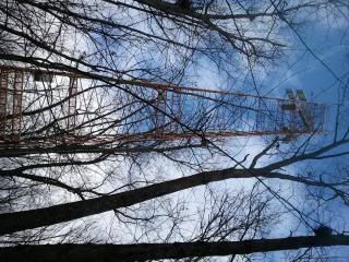
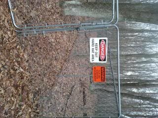
Out on a couple mile hike this morning with Mrs Grizzflyer, in Oak Openings. Saw a tower there I hadn't noticed before, 4-legged, yellow, about 40-50 feet high. Had some rectangular reflectors at the very top. Possibly solar panels, but they looked very small to produce much power, and half of them were facing the wrong direction get get the sun. It was surrounded by a 6-foot chain link fence. Only signs were Danger -Hard Hat Area and Warning -Flux and Radiation Measurements. It had a number of rain gauges surrounding it, outside the fenced-in area. It is located west of Wilkins Rd, south of the Wabash Cannonball Trail, east of the bike trail, and not too far off the blue foot trail.
Anybody know what it is and what the purpose of it is? I'm guessing some type of atmospheric monitoring or research site. I'd love to have it in my back yard, great to hang antennas off of. Hmmm, wonder if they would let us place a geocache there, at the top? Probably not.
What is it?
Moderator: Steering Committee
- GrizzFlyer
- Frequent Poster (200 - 499 posts)
- Posts: 367
- Joined: Wed 2003-04-30, 00:00:00
- Location: Monclova Township, Ohio
- cheechgang
- Obsessed Lvl Poster (3k+ posts)
- Posts: 5721
- Joined: Fri 2004-03-26, 00:00:00
- Location: Monclova Township, OH
Re: What is it?
As the study has been published maybe they will let you have the tower for your antennae.
- GrizzFlyer
- Frequent Poster (200 - 499 posts)
- Posts: 367
- Joined: Wed 2003-04-30, 00:00:00
- Location: Monclova Township, Ohio
Re: What is it?
Ah yes, Evapotranspiration. I should have known.
Yep, I'll take that tower, I'll even take it down for them.
Re: What is it?
One of my best friends did her master project at that tower
It measures a whole ton of environmental stuff. She was studying carbon. The green cone looking things around were here.